 Zambia Geoportal (Demo)
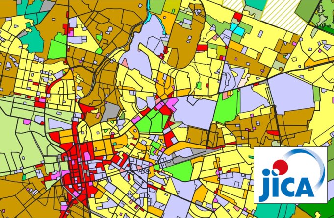
Regional Land Use Plan for Greater Lusaka
Regional Land Use Plan for Greater Lusaka created by Greater Lusaka RDP (JICA)
Simple
- Date (Publication)
- 2025-01-31T12:11:00+00:00
- Status
- On going
- Point of contact
-
Organisation name Individual name Electronic mail address Role MINISTRY OF LOCAL GOVERNMENT AND RURAL DEVELOPMENT
Chilombo Mbilika Hamabwe
Point of contact
- Maintenance and update frequency
- Unknown
- Theme
-
-
Land use, land cover
-
Land use, land cover
-
- Access constraints
- Copyright
- Use constraints
- otherRestictions
- Spatial representation type
- Vector
- Denominator
- 50000
- Language
- English
- Character set
- UTF8
- Topic category
-
- Boundaries
- Utilities communication
- Transportation
- Begin date
- 2025-01-31
N
S
E
W
))
- Reference system identifier
- WGS 1984
- OnLine resource
-
Protocol Linkage Name OGC:WMS
https://www.znsdi.net/geoserver/gn/wms? LULC_Lusaka
WWW:DOWNLOAD-1.0-http--download
https://www.znsdi.net/srv/api/records/3aa2d3bf-67fd-486b-8ef0-55133b1e68a3/attachments/LU.zip
- Hierarchy level
- Dataset
Metadata
- File identifier
- 3aa2d3bf-67fd-486b-8ef0-55133b1e68a3 XML
- Metadata language
- English
- Character set
- UTF8
- Date stamp
- 2025-07-13T17:57:29.998201Z
- Metadata standard name
-
ISO 19115:2003/19139
- Metadata standard version
-
1.0
- Metadata author
-
Organisation name Individual name Electronic mail address Role MINISTRY OF LOCAL GOVERNMENT AND RURAL DEVELOPMENT
Chilombo Mbilika Hamabwe
Point of contact
)))